
Regional Polymetallic Nodule Exploration
Polymetallic nodules were first discovered on the ocean floor in 1873 by the HMS Challenger, 250 km southwest of Ferro Island in the Canary Group, Atlantic Ocean (Murray and Renard, 1891). This pioneering expedition circled the globe and traversed both the western CCZ and parts of the south Pacific although not the Cook Islands EEZ (Figure 3-1 xxx).
The possibility of exploiting polymetallic nodules was not seriously considered until the middle of the 20th century. Glasby et al. (1980) noted that while studies were investigating distribution of seafloor nodules through the Pacific in the mid-20th century, there was an absence of data for the southwest Pacific. The expedition to find significant abundances in the region was the Scripps Downwind expedition of 1957 (Menard and Shipek, 1958).
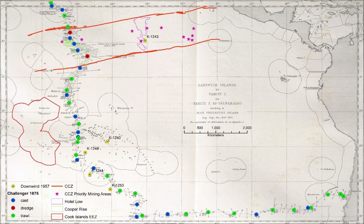
South Pacific transects and sample stations for HMS Challenger 1875 and Downwind 1957. Location data from Natural History Museum UK, (2014) and (Menard and Shipek, 1958); CCZ features from (Parianos and Madureira, 2021).
It was not until 1974, when an English translation of Skornyakova and Andrushchenko (1970) was published, that a generalised map of nodule distribution in the Pacific became available. The expansion of research efforts into polymetallic nodules in the southwest Pacific resulted from the expansion of the study of oceanography in general and a need for smaller island nations in the South Pacific to understand the seabed resource around them (Glasby et al. 1980). With rapidly increasing interest in seabed nodules in the region, The Committee for Coordination of Joint Prospecting for Mineral Resources in South Pacific Offshore Areas (CCOP/SOPAC) was established in 1972. This was an intergovernmental, regional organisation with 21-member countries, under the Economic and Social Division of the United Nations. The purpose of CCOP/SOPAC was to promote offshore mineral and petroleum prospecting.
In the 1980s, following the protracted development of the Clarion Clipperton Zone and The United Nations Convention on the Law of the Sea (Lipton et al., 2016), SOPAC co-ordinated an extensive regional exploration programme including the territorial waters of Kiribati, Tokelau and the Cook Islands. A wide range of exploration groups were involved, such as Ifremer (L'Institut Français de Recherche pour l'Exploitation de la Mer), but much of the systematic work was carried out by JICA/MMAJ (Japan International Cooperation Agency/Metal Mining Agency of Japan).
Nodule Exploration in the Cook Islands
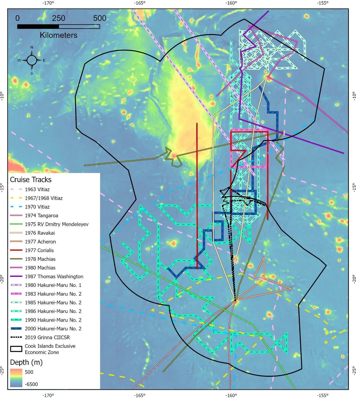
The first expeditions to definitively identify the presence of nodules in the Cook Islands were those of the RV Vitiaz (1963–1970) and RV Dmitry Mendeleyev (1975) (Skornyakova et al., 1990). These were under the leadership of P L Bezrukov, who secured a marine scientific research permit from the Cook Islands government, who also supplied T Marsters as an observer. The expedition is thought to have taken samples by dredge around the southern island group and in the south Penryn Basin . In 1974, the RV Tangaroa completed a circuitous sampling transit from New Zealand that included the seas south of Rarotonga.
The 1976 Ravakai expedition by SOPAC built on the results of the previous work with this expedition being the first of several that utilised locally based ships. The expedition collected twelve free-fall grab samples in the western side of the Penrhyn Basin returning across the Manihiki Plateau. This was followed by the 1977 Acheron expedition around the southern group; the UNDP Charter Vessel Machias which is believed to have conducted short expeditions between 1977 and 1980; and an early voyage of the RV Sonne (SO6) in 1978.
In 1980, the Geological Survey of Japan carried out the Wake-Tahiti Transect which passed through the CIEEZ (Usui, 1984). In addition to the Wake-Tahiti transect, more detailed studies were carried out along the transect of interest to the Cook Islands including the GH83-3 area (area 14-160;) in the southern Penrhyn Basin (Usui, 1994).
Then in 1985, the Japan/SOPAC Co-operative Study on Deep Sea Minerals Resources in the South Pacific commenced what is by far the most important polymetallic nodule sampling programme in the Cook Islands region to date. The first phase of this programme (1985–1994) consisted of three expeditions in the Cook Islands region on the Hakurei-Maru No. 2 in 1985, 1986 and 1990 (Cronan, 2013). The first two expeditions took place in the Penrhyn Basin and the third in the southern Cook Islands.
In 1987, Scripps used the Thomas Washington, to conduct transects in the North Penrhyn Basin. Unlike previous nodule expeditions in the CIEEZ, which mostly had a resource evaluation aim, the expedition was designed to collect polymetallic nodules and associated sediments in a range of sedimentary environments in order to understand the factors causing variability in the nodules, and to use this knowledge in the construction of a geological/chemical model to aid in future nodule exploration in the region (Cronan, 1987; Cronan and Hodgkinson, 1994).
In 2000, the Japan/SOPAC Co-operative Study carried out a follow up expedition in the Cook Islands region on the Hakurei Maru No. 2, surveying areas in more detail in particular the Central Area (16-159). The results served to confirm and refine the conclusions from earlier expeditions with regards to the location of polymetallic nodules and the relative quality of the 16-159 area (JICA/MMAJ, 2001).
Other expeditions through the 1990s and 2000s tended to focus on the Manihiki Plateau, until 2019/2020 when commercial groups carried out two marine scientific research expeditions using the local ship MV Grinna to confirm grades and quality of the nodules in their reserved areas in the south Penrhyn Basin.
In February 2022, three exploration licenses were granted to commercial companies wanting to explore the possibility of commercial development of high cobalt nodules in the Cook Islands EEZ. The first of these companies started exploration in early July 2022 using the MV SeaSurveyor.
Cook Islands nodule sampling expeditions
Below are expeditions that have been carried out in Cook Island waters (EEZ):
research vessel (year of survey/cruise #)
survey area
surveyed commodity
RV Vema (1962/18)
Manihiki Plateau
Seismic survey, seabed sediments
RV Vitiaz (1963/37)
Penrhyn Basin & south-western Cook Islands
Polymetallic nodules
RV Vitiaz (1967_1968/43)
Southern Cook Islands
Polymetallic nodules
RV Vitiaz (1970/48)
Penhryn Basin and southern Cook Islands
Polymetallic nodules
RV Chain (1971/100)
Manihiki Plateau
Seismic survey
RV Washington (1972/SOUTHTOW 10, 11, 12)
Manihiki Plateau
Seismic survey and dredging
RV Melville (1972/CATO 3)
Manihiki Plateau
Seismic survey and dredging
Glomar Challenger (1973/DSDP 33)
Manihiki Plateau
Seabed drilling
RV Vitiaz
Cook Islands
Polymetallic nodules
RV Tangaroa (1974)
Rarotonga, Cook Islands
Polymetallic nodules
RV Dmitry Mendeleyev (1975/14)
Southern Cook Islands
Polymetallic nodules
MV Ravakai (1976)
Area between Rarotonga and Penrhyn
Polymetallic nodules, Metalliferous sediment and Phosphate
RV Acheron (1977)
Southern Group, Cook Islands
Precious coral, Manganese nodules
RV Machias (1977)
Northeast of Rarotonga
Polymetallic nodules
RV Machias (1978)
Penrhyn and Samoa Basins, Nearshore waters of the Cook Islands
Polymetallic nodules and Precious Coral
RV Sonne (1978/SO6)
Aitutaki Passage
Polymetallic nodules
RV Machias (1980a)
Northern Cook Islands
Polymetallic nodules and Precious coral
RV Machias (1980b)
East of Penrhyn Island, Penrhyn Basin, Penrhyn, Manihiki, Nassau Islands
Polymetallic Nodules, Precious coral and Phosphate
RV Sonne (1980)
Aitutaki Passage
Polymetallic Nodules
RV Hakurei Maru (1980)
South Penrhyn Basin
Polymetallic Nodules
MV Ravakai (1983)
Slopes of Rakahaga and Manihiki Atoll
Precious Coral
RV Hakurei Maru (1983)
South Penrhyn Basin
Polymetallic Nodules
RV Sonne (1984/SO35-1)
Manihiki Plateau
Seabed sampling
RV Hakurei Maru 2 (1985)
Western Penhryn Basin, eastern margin of the Manihiki plateau and the North of Penrhyn Island.
Polymetallic Nodules
HMNZS Tui (1986)
Manihiki Plateau and adjacent Southwest sea areas
Cobalt-rich crust, Polymetallic nodules
RV Hakurei Maru 2 (1986)
Western edge of the southern Penhryn Basin (to the east of the Manihiki plateau)
Polymetallic Nodules
RV Moana Wave (1987)
Cook Islands: Suwarrow trough, eastern Manihiki Plateau, Rakahaga-Manihiki island area
Cobalt-rich crust and Metalliferous sediments
RV Thomas Washington (1987)
Northern Cook Islands and adjacent High Seas
Polymetallic nodules, Cobalt-rich crust, Deep sea sediment
RV Sonne (1990/S067)
North-east edge of Manihiki Plateau
Complex of Volcanic Cones and mineral resources
RV Hakurei Maru 2 (1990)
Southern Cook Islands
Polymetallic Nodules
RV Hakurei Maru 2 (2000)
Central Cook Islands (i.e. Southern Penrhyn Basin)
Polymetallic Nodules
RV Sonne (2007/SO193)
Manihiki Plateau and Samoa Basin
Ferro-manganese crusts and Polymetallic nodules
MV Grinna (2019)
SPB Central area (CIIC-SR reserve area)
Polymetallic Nodules
MV Grinna (2019/2020)
SPB Central area (OML reserve area)
Polymetallic Nodules
Last updated: December 12 2022