useful data links
Below are global data sources relevant for seabed minerals (in alphabetical order)

Australian Ocean Data Network
Australian Ocean Data Network holds data records in Research Data Australia, which cover 9076 subjects areas including EARTH SCIENCE and OCEANS
Bathymetric Data Center
Bathymetric data sets from German marine research are collected and archived here.

Bathymetric Data viewer
NOAA (National Oceanic and Atmospheric Administration) is the primary source of bathymetric data for the world's oceans. See their Bathymetry and Global Relief website.
Chlorophyll Concentration
Shows where tiny, floating plants - phytoplankton - live in the ocean

Cook Islands Biodiversity Database
Holds taxanomic and location data of the biodiversity found in the Cook Islands

Copernicus
Provides complete, free and open access to Sentinel-1, Sentinel-2, Sentinel-3 and Sentinel-5P user products, starting from the In-Orbit Commissioning Review (IOCR).

Deep Data
The ISA Deep Seabed and Ocean Database hosts all deep seabed activities related data and in particular, data collected by the contractors on their exploration activities, as well as any other relevant environmental and resources related data for the Area.

Deep Sea Mining Watch
Map of Clarion Clipperton Zone tenements
EPSG.IO
EPSG.io makes it easy to search and explore coordinate reference systems (CRS) and transformations. It connects CRS data, areas, and methods in one fast, reliable, and free platform with web and API access — simplifying geospatial work worldwide.

GEBCO Gazetteer
GEBCO maintains and makes available a digital gazetteer of the names of features on the ocean floor. The GEBCO Sub-Committee on Undersea Feature Names (SCUFN) is responsible for the maintenance and update of the gazetteer data set.

Gebco Grid
GEBCO’s current gridded bathymetric data set, the GEBCO_2021 Grid, is a global terrain model for ocean and land, providing elevation data, in meters, on a 15 arc-second interval grid.
Research Data at GEOMAR
Centre for Ocean Research

Geotraces
An International Study of the Marine Biogeochemical Cycles of Trace Elements and Isotopes

Global Sediment
National Centers for Environmental Information's global ocean sediment thickness grid.
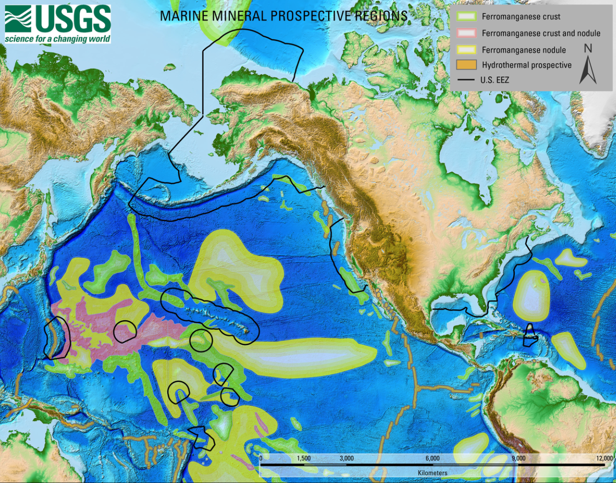
Global Marine Mineral Prospective Regions Map
A map showing Global Marine Mineral Prospective Regions, including those that occur within the United States Exclusive Economic Zone.

ITS
Integrated Taxanomic Information system. Here you will find authoritative taxonomic information on plants, animals, fungi, and microbes of North America and the world.
JICA
View articles, cruise reports, maps and so much more via this database

Marine Sand Watch
This platform monitors large vessels dredging sand, sediment and rock in the marine environment all around the world
Marlin3
CSIRO Oceans & Atmosphere Marlin Data Catalogue.
Ocean Data and Information System
ODIS is a digital ecosystem in which a global community of organisations – large and small – share and exchange their (meta)data to better understand and steward the Ocean.
Pacific Data Hub
The Pacific Data Hub (PDH), is a central repository of data about the Pacific and from the Pacific. The platform serves as a gateway to the most comprehensive collection of data and information about the Pacific across key areas including population statistics, fisheries science, climate change adaptation, disaster risk reduction and resilience, public health surveillance, conservation of plant genetic resources for food security and human rights..

Pangaea
Data Publisher for Earth & Environmental Science. Generally open for archiving, publishing, and re-usage of data. The World Data Center PANGAEA is member of the World Data System.

Protected Seas Interactive Map
Navigator is a free, interactive map of regulatory information for over 21,000 managed saltwater and coastal areas worldwide, including the High Seas.
OBIS
Global open access database for marine biodiversity data
Seapodym
A spatial ecosystem and population dynamics model with parameter optimization providing a new tool for fish management.

World Digital Magnetic Anomaly Map
Compilation of magnetic anomalies caused by the Earth lithosphere, on continental and oceanic areas, in a comprehensive way, all over the World.

World Ocean Atlas
The World Ocean Atlas (WOA) is a collection of objectively analyzed, quality controlled temperature, salinity, oxygen, phosphate, silicate, and nitrate means based on profile data from the World Ocean Database (WOD).

World Register of Marine Species
A classification and catalogue of marine names.