
E/V Nautilus Expedition Deepens Cook Islands Understanding of our Marae Moana
Collaborative expedition combines local knowledge and global expertise to study deep habitats in Cook Islands waters
The E/V Nautilus has completed a 21-day research cruise across priority deep-sea areas of the Cook Islands’ Marae Moana and wrapped up its portside engagements in Rarotonga before departing our shores.
From October 1 to 21, 2025, a Cook Islands delegation sailed alongside the U.S. and international experts to map the seafloor, observe deep-sea habitats, and share the experience with communities back home through live ship-to-shore connections.
Imagery and observations collected during the expedition are now moving through processing and quality control ahead of public release.
Key Facts
Expedition: NA176 “Deep-Sea Habitats of the Cook Islands” (1–21 October 2025)
How we explored:
Remotely operated vehicles (ROV Little Hercules and ROV Atalanta)
High-resolution seafloor mapping
Telepresence, allowing Cook Islands schools and communities to connect live
Where we looked:
North of Aitutaki – abyssal seafloor at approximately 2,150–5,200 m depth
Manihiki Plateau – approximately 1,100–1,250 m depth for habitat characterisation
New technology:
The MxD SeaCam subsea camera system, integrated onto ROV Little Hercules, captured ultra-high-resolution imagery, from broad seafloor views to crisp close-ups of organisms and substrate.
Data promise:
Once processed and quality-checked, expedition data will be archived in public repositories and shared with the Cook Islands Government to support future research and decision-making under Marae Moana.
Importantly, this mission was exploration and research only. No seabed mining is authorised in the Cook Islands.

People and Partnership
The expedition was a collaboration between the Cook Islands Seabed Minerals Authority (SBMA), NOAA Ocean Exploration (via the Ocean Exploration Cooperative Institute – OECI), and the Ocean Exploration Trust (OET).
A Cook Islands delegation joined the Nautilus science and engineering teams throughout the cruise, contributing local knowledge and perspectives while building national capacity in deep-ocean research.
Voices of the Voyages
SBM Commissioner Beverly Stacey Ataera said:
“Meitaki ma‘ata to the E/V Nautilus crew, our Cook Islands team, and partners at NOAA Ocean Exploration and the Ocean Exploration Trust. Every image and observation strengthens our ability to make science-led, transparent decisions about our moana for generations to come.”
Hon. Mark Brown, Prime Minister and Minister Responsible for Seabed Minerals, said:
“This partnership shows the Cook Islands at our best - working with world-class scientists while keeping our values at the centre. We can only care for what we truly understand, and this expedition deepens our understanding of the deep ocean within our Marae Moana.”
NOAA Administrator Neil Jacobs, Ph.D., said:
“The success of this expedition underscores the power of international collaboration in advancing ocean exploration and sustainable resource management. We deeply value our relationship with the Cook Islands, and we are proud to be a key partner in the mission to advance the understanding and management of their marine environment while prioritising environmental stewardship and identifying key areas for economic development.”
What We Saw (Preliminary Observations)
During the cruise, the team recorded a range of deep-sea life and seafloor features, including:
a rare bigfin squid (Magnapinna)
dumbo octopods
faceless cusk eels
diverse sediment textures and structures
areas of nodule fields and associated habitats.
These are observations, not final conclusions. Full scientific analysis will follow once all data and imagery have been processed and reviewed.
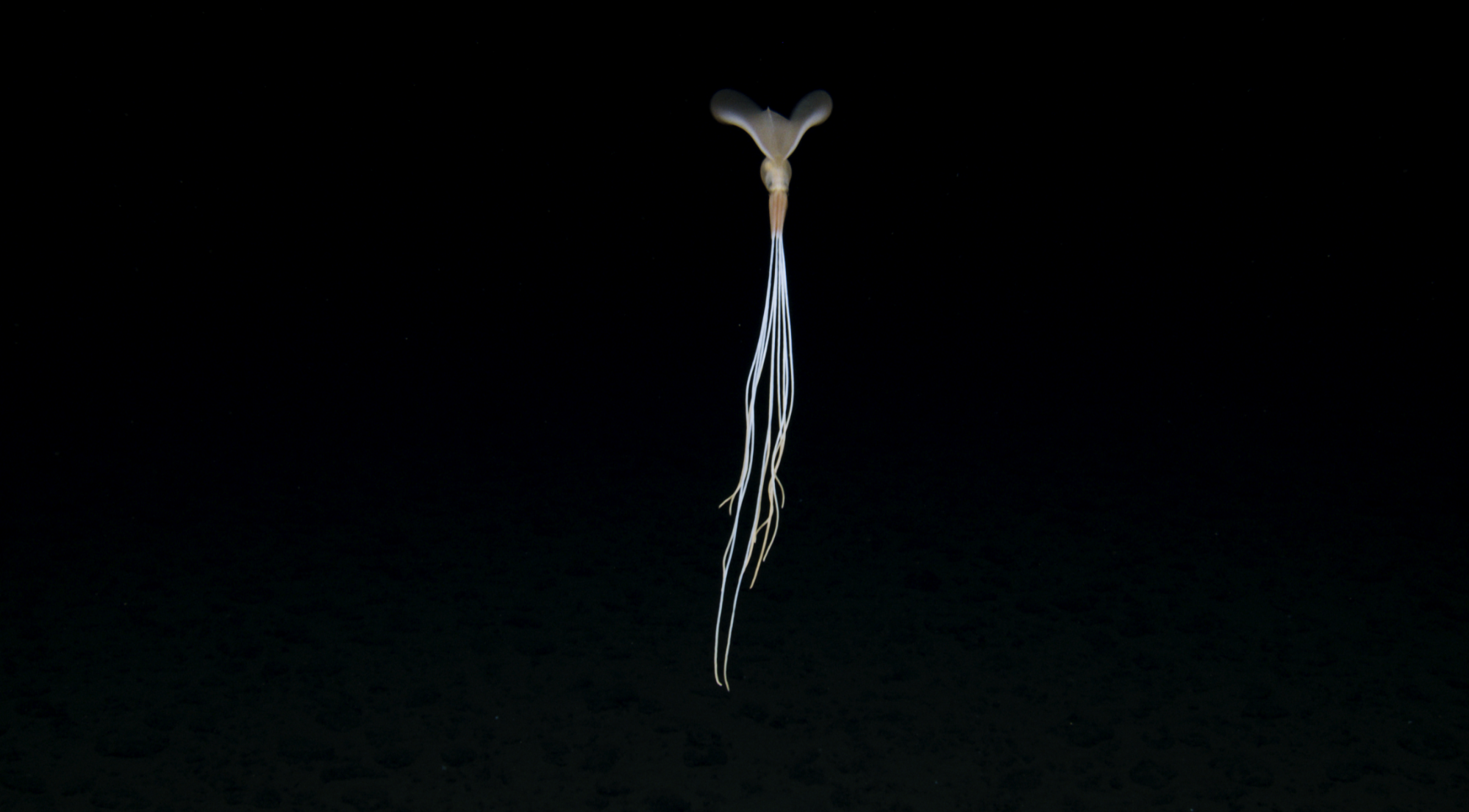
Image credit: Ocean Exploration Trust, Deep Sea Rare Bigfin Squid (Magnapinna)

Image credit: Ocean Exploration Trust, Dumbo Octopod

Image credit: Ocean Exploration Trust, Faceless Cusk Eel
Why It Matters
For communities, clearer pictures of our deep ocean help us talk openly about how to care for it.
For decision-makers, stronger environmental baselines give a better foundation for evidence-based choices about any future activities in our waters.
For students and lifelong learners, telepresence and open data turn the deep sea from something distant into something we can all see, question, and learn from together.
What's next - Data & Transparency
Over the coming months:
Imagery, mapping products, and other data will move through quality control and analysis.
Consistent with partner commitments, data will be:
provided to the Cook Islands Government, and
archived in publicly accessible repositories to support ongoing research and education.
SBMA will host local briefings to share key findings, answer questions, and explain how this new knowledge will be used within the Ecosystem-Based Management Framework under Marae Moana.