
SBMA’s new map illustrates never before seen ocean floor features

Seabed Minerals Authority Senior Technical Officer Rima Browne has led the creation of a new seabed map – the first of its kind for the Cook Islands – that was recently published in the international publication Journal of Maps.
This new seabed geomorphology map will help provide a better understanding of marine environment habitats and mineral potential, which is a important considering the Cook Islands is 99.99% ocean and seabed.
Geomorphology is the study of landforms or in this case the form of the seabed.
The map was made using special geographic software and based on similar data as used by Google Maps on phones or computer screens.
“The interpretation process was painstaking and involved emphasising different underwater features,” said Browne. “We identified and defined seabed plains, mountain ranges, canyons, details of the Manihiki Plateau and other features.”
“You probably notice when you zoom into Google Maps for the seabed, you can only go so far before the details start to blur,” said Browne. “At the 1:3,000,000 scale of the map, Rarotonga is only 0.5 cm across…but our seabed is so large we had to use the largest standard paper size to fit the map”.
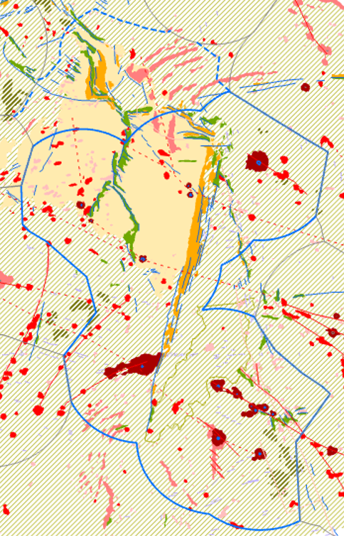
The newly interpreted seabed geomorphology map of the Cook Islands.

Browne and Parianos pose with their new map.
Assisting in the creation of the map were SBMA Technical Director John Parianos and consultant Alain Murphy, who both have a wealth of experience in this area.
“Having done a similar interpretation for my PhD, I was eager to do the same for the Cook Islands,” said Parianos. “It was also great to work with Rima, as she went through the process of making the map and getting it published. Alain was a great help in reality checking the map and adding important details.”
The map went through a careful peer review process before being accepted for publication and can now be downloaded from the Journal of Maps website - an academic journal that focuses on geography and map making. The map is accompanied by a paper which explains how the map was made, as well as many of the main features.
“The map and paper were immediately accepted by the reviewers, which was really pleasing.” said Browne. “They made some nice compliments – I think they really appreciated how we were able to use the data in this way. We also got expert feedback from Natural Heritage Trust and Infrastructure Cook Islands."
The map has many applications, including contributions to the seabed component of the Marae Moana spatial management plan - which aims to zone marine activities within the Cook Islands.
“The Cook Islands has a really distinctive geological history,” said Browne. “We learnt some things in making the map, but there are other unanswered questions that we are curious about. Hopefully this map will help enable future discoveries on the seabed.”
Queries may be directed to Kaitini Herman: kaitini.herman@cookislands.gov.ck
Seabed Minerals Authority